| Info | |
| color red, other | |
| Name - by itinerary | Warta , Wojków |
| Name - given | Szlak Powstańców 1863 r. |
| length | 50 km |
| Accessibility |
1. For independent wheelchair users: difficult access
2. For those with limited mobility but can manage a few steps: difficult access
|
| | |
| Descripton of whole route | |
| Description of itinerary | Warta - Cielce - Poprężniki - Poniatów - Goszczanów - Stojanów - Chlewo - Morawki - Sędzimirowice - Skalmierz - Suliszewice - Kołdów - Błaszki - Żelisław - Sarny - Gruszczyce - Wrząca – Wojków |
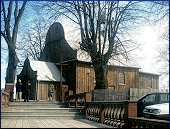
| Further info | Marked with red, walking route called “Szlak Powstańców 1863” (guerrillas route) starts by the Muzeum Miasta i Rzeki Warty (River and the City of Warta Museum) in Warta. Route leads through towns of sieradzki municipality linked with the January Uprising. Towns lie on the Turecka and Złoczewska Height. |
| Info for the disabled | |
| Terrain - slope | |
| Terrain - levels difference | m |
| Path - the smallest width | m |
| Terrain - bumpy | |
| Terrain - cross trough | |
| Track cross active motor-road | |
| Track goes by side active motor-road | |
| Terrain - WC | Yes |
| | |
| Description of start point | |
| Country | Poland |
| Voivodeship | łódzkie |
| District (Gmina) | Warta |
| City | Warta |
| Tourists routes node | no data |
| Location | |
| Access - by public transportation | Yes |
| Access - public transportation - adapted | no data |
| Access - description | |
| Access - distance | 0 |
| Parking | Yes |
| WC | |
| Place description | |
| | |
| Description of end point | |
| Country | Poland |
| Voivodeship | |
| District (Gmina) | |
| City | |
| Tourists routes node | no data |
| Location | |
| Access - by public transportation | Yes |
| Access - public transportation - adapted | no data |
| Access - description | |
| Access - distance | 0 |
| Parking | Yes |
| WC | |
| Place description | |
| Photos | | |
|
 |
 |
| |

