| Info | |
| color blue, other | |
| Name - by itinerary | Poddębice, Kłudna PKP |
| Name - given | Szlak im. Marii Konopnickiej |
| length | 16 km |
| Accessibility |
1. For independent wheelchair users: difficult access
2. For those with limited mobility but can manage a few steps: difficult access
|
| | |
| Descripton of whole route | |
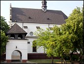
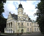
| Description of itinerary | Route:
Poddębice - Klementów - Karnice - Bronów - Kłudna PKP (Polish State Railways station)
Marked with blue, route called ‘Szlak im. Marii Konopnickiej’ starts in Poddębice. The route crosses towns connected with the stay of the famous Polish writer and poet Maria Konopnicka. She lived on Poddębice land from 1862 till 1876. |
| Further info | |
| Info for the disabled | |
| Terrain - slope | |
| Terrain - levels difference | m |
| Path - the smallest width | m |
| Terrain - bumpy | |
| Terrain - cross trough | |
| Track cross active motor-road | |
| Track goes by side active motor-road | |
| Terrain - WC | Yes |
| | |
| Description of start point | |
| Country | Poland |
| Voivodeship | łódzkie |
| District (Gmina) | Poddębice |
| City | Poddębice |
| Tourists routes node | no data |
| Location | |
| Access - by public transportation | Yes |
| Access - public transportation - adapted | no data |
| Access - description | |
| Access - distance | 0 |
| Parking | Yes |
| WC | |
| Place description | |
| | |
| Description of end point | |
| Country | Poland |
| Voivodeship | |
| District (Gmina) | |
| City | |
| Tourists routes node | no data |
| Location | |
| Access - by public transportation | Yes |
| Access - public transportation - adapted | no data |
| Access - description | |
| Access - distance | 0 |
| Parking | Yes |
| WC | |
| Place description | |
| Photos | | |
|
 |
 |
| |

