|
No sticking up
Advertisements!
Your IP
216.73.216.165
 Projekt współfinansowany ze środków Unii Europejskiej
|
Touristic routes
| Info | |
| color red, other | |
| Name - by itinerary | Radomsko, Brudzewice |
| Name - given | Szlak Partyzancki im. majora Henryka Dobrzańskiego - "Hubala" |
| length | 201 km |
| Accessibility |
1. For independent wheelchair users: difficult access
2. For those with limited mobility but can manage a few steps: difficult access
|
| | |
| Descripton of whole route | |
| Description of itinerary | Radomsko - Wygoda - Ojrzeń - Włynice - Ewina - Kotlin - rezerwat "Jasień" (Jasień reserve) - Karsy - Kobiele Wielkie - Teodorów - Smotryszów - Biestrzyków Mały - Leonów - rezerwat "Góra Chełmo" (Góra Chełmo reserve) - Chełmo - Strzelce Małe - Masłowice - Przedbórz - Dęba - Bąkowa Góra - Zbyłowice - Majkowice - Łęg Ręczyński - Placówka - Trzy Morgi - Przewóz - Winduga - Biała - Kurnędz - Sulejów - Przygłów - Włodzimierzów - Kłudzice Nowe - Kleszcz - Meszcze - Polichno - Golesze Duże - Dębsko - Swolszewice Małe - Groty Nagórzyckie - Tomaszów Mazowiecki - Wilanów - Kaczka - Glinnik - Spała - Teofilów - Inowłódz - Fryszerka - Anielin - Studzianna - Poświętne - Małoszyce – Brudzewice |
| Further info | Walking route marked with red, called ‘Szlak Partyzancki im. mjr. Henryka Dobrzańskiego "Hubala", crosses places marked with blood of guerrillas and soldiers of the Polish Army fighting in the defence of Poland in 1939 and later Nazis occupation.
The route starts in Radomsko and goes through Ojrzeń, Ewinę, "Jasień" reserve, Kobiele Wielkie, Górę Chełmo, Przedbórz, Bąkową Górę, Majkowice, Sulejów, Witów, Polichno, Golesze, Nagórzyce, Tomaszów Mazowiecki, Spałę, Inowłódz, Anielin, Poświętne. It follows to Drzewica and further to the łódzkie voivodeship border. |
| Info for the disabled | |
| Terrain - slope | |
| Terrain - levels difference | m |
| Path - the smallest width | m |
| Terrain - bumpy | |
| Terrain - cross trough | |
| Track cross active motor-road | |
| Track goes by side active motor-road | |
| Terrain - WC | Yes |
| | |
| Description of start point | |
| Country | Poland |
| Voivodeship | łódzkie |
| District (Gmina) | Radomsko |
| City | Radomsko |
| Tourists routes node | no data |
| Location | |
| Access - by public transportation | Yes |
| Access - public transportation - adapted | no data |
| Access - description | |
| Access - distance | 0 |
| Parking | Yes |
| WC | |
| Place description | |
| | |
| Description of end point | |
| Country | Poland |
| Voivodeship | |
| District (Gmina) | |
| City | |
| Tourists routes node | no data |
| Location | |
| Access - by public transportation | Yes |
| Access - public transportation - adapted | no data |
| Access - description | |
| Access - distance | 0 |
| Parking | no data |
| WC | |
| Place description | |
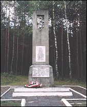
| Photos | | |
| 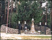 |
 |
| |
|
